Planning to visit any destination for the first time can sometimes bring Goosebumps to travelers. This is more common with inexperienced travelers. All travelers need sufficient information to support their decision to travel to any area. If the travelers’ destination of choice doesn’t exist on any map, the fear is even worse. The visitors who come to the Ruboni community camp are not exceptional as they have repeatedly asked the travel questions requiring the same kind of information.
News has come through that; Ruboni Community Conservation and Development Program (RCCDP) is working with the local community members to map Ruboni village tourism attractions, on the open street map. In the month of May 2022, Ruboni Community Conservation and Development Program (RCCDP) kick-started this 12 months project of mapping Ruboni village tourism attractions, being implemented with financial and technical support being provided by the Open Mapping Hub – Eastern and Southern Africa.
As the word “open” suggests, the map that will be made will be open for use by any person, without requiring any licenses or payments. From the time this mapping exercise will be finished, Ruboni village will be openly visible to travelers. The tourist, tour operators, and tour guides will especially benefit from this map once it is completed, as they will be able to easily plan and explore Ruboni village. You can read on… to learn more about this initiative, and how and when this map of Ruboni village will be available for use.
From talking to one of the tourism service providers in Ruboni village, you will learn that guests who visit Ruboni village have always asked to know where Ruboni village is located, how far it is from the nearest biggest town (Kasese), what activities can they do in Ruboni, whether Ruboni is accessed by car and how the road status is. This demonstrates a lack of sufficient destination information about Ruboni village, in the market.
The above, and other related factors specific to Ruboni village have inspired an innovative community mapping initiative, to generate, prepare and upload the important travel information required by guests who choose to come to Uganda and Ruboni village in the Rwenzori foothills. Under this mapping initiative, this kind of information will be placed online so that visitors can find it handy without necessarily making a call. The data will be used by all tourism service providers, business owners, the local and central government planning departments, travelers and other tourism facilitators.
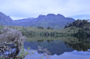
Ruboni village is located in the Rwenzori foothills, at the entrance to the central circuit gate of Rwenzori Mountains National Park. Ruboni is the starting point for the eight-day trek to margarita peak (5109m Asl). The central circuit is the historical trail that pioneered tourism in the Rwenzori Mountains, around the year 1906 when the duke of Abruzzi and other explorers visited this landscape of global influence.
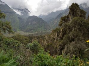
The area to be mapped by this intervention, stretches for 17km west along the Mubuku valley, from the Kasese-fort portal road to the park gate at Mihunga, and extends north and south, into the two sub-counties of Bugoy and Maliba. River Mubuku is the boundary of these two sub-counties
Every travel plan includes a map. Ruboni village being a tourist destination has always needed to be on one too. For over seventy years of tourists visiting Ruboni village, the guest direction information has been based on guesswork. This has always made it hard for the local tourism players to provide consistent information or sell their tourism products, and for the visitors to find or explore Ruboni village attractions.
Ruboni village being an international travel destination, lack of a map crates challenges for all sorts of global tourism players in the value chain including international tour agents, Online travel agents (OTA), tour operators, tour guides, and the local tourism service providers.
In response to the increasing tourist need for sufficient information about Ruboni, the Ruboni community in partnership with tourism stakeholders is mapping the Ruboni tourism village for the first time. Through this partnership, Ruboni village’s active and potential tourist attractions will be added to the open street map, tools provided to collect and manage mapping data, create further mapping partnerships, and local community members will be trained to continue updating the map after the project end.
Until now, no one in or out of Ruboni village has ever provided a better answer to the traveler’s questions, than this initiative of adding the Ruboni tourist attractions to the editable and interactive digital global map. The work will bring together all attractions in Ruboni village including; accommodation facilities, trails, tourist centers, crafts markets, and other social points of relevance.
There is no doubt that the lack of Ruboni tourism destination information has for a long time compromised attraction visibility, accessibility, and visitor satisfaction in Ruboni village. Under the project; mapping Ruboni community tourist attractions; RCCDP will consolidate all the existing and potential tourist attractions in Bugoye and Maliba sub-counties; the gateway to the Nyakalengijo central circuit gate of Rwenzori Mountains National Park to enhance their collective marketing.
Ruboni Community Conservation and Development Program (RCCDP), is the leading and implementing organization of the mapping activity. RCCDP will mobilize and lead the entire stakeholder network to implement and own the project results. You can contact Ruboni Community if you want to learn more information about this mapping activity.
This mapping work is being supported by the Humanitarian Open Street Map Team (HOT). The local organizations partnering with RCCDP on the mapping project are; the Uganda Community Tourism Association (UCOTA), Ibanda-Kyanya town council, Kasese District Local Government (KDLG), and the Best Tourism Villages initiatives, upgrade program of the United Nations Tourism Organisation (UNWTO). Other stakeholders include; the ministry of tourism, tour operators and guides, the tourism destination managers, and local service providers
After this noble action of mapping Ruboni village tourism attractions, the local tourism businesses will definitely have a better placement in the market, enhancing their competitiveness. On the other hand, travelers from anywhere in the world, tour operators, and tourist guides will be able to explore Ruboni tourism village, both from a distance as they plan their trips and during their visit to explore the different attractions in the village.